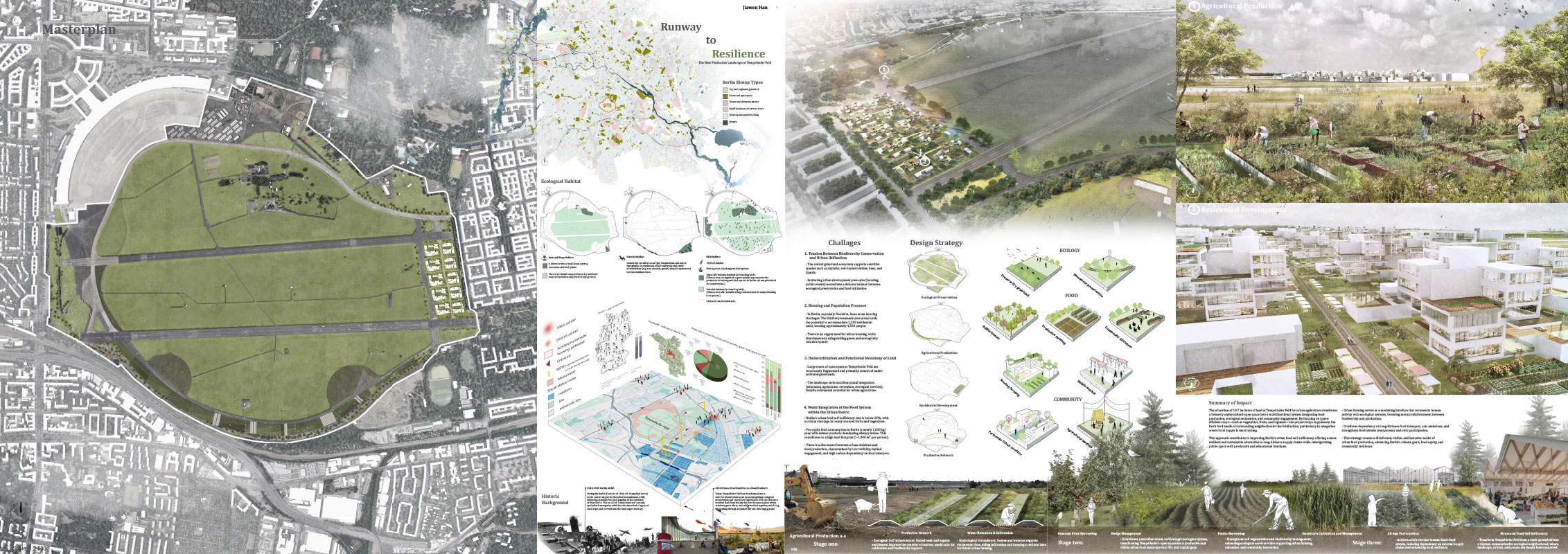

Jiawen Han
Project background
Tempelhofer Feld was once a military airport and a key site of the 1948–49 Berlin Airlift, symbolising food relief in times of crisis. Today, it is being reimagined as an urban commons centred on ecology, food, and community resilience. The project responds to four key urban challenges in Berlin: Biodiversity conservation, Housing shortage, Monofunctional land use, and externalised food supply.
Ecology & Climate
Berlin is one of Europe’s greenest cities, with abundant parks, forests, and water bodies. Its temperate continental climate and sandy soils support both urban farming and drought-tolerant ecosystems.
Species–Habitat–Design Responses
Skylarks nest in open meadows → Farmlands are sited away from breeding zones and buffered with low-disturbance planting. Lizards depend on sun-exposed soils → Gravel margins and sandy microhabitats are preserved along field edges. Bees and wasps forage in flower-rich areas → Pollinator corridors with native plants are integrated into the agricultural layout.
Urban Agriculture Potential
- The site’s flat land, full sunlight, and well-drained sandy soils make it ideal for shallow farming and greenhouses.
- Existing rainwater reservoirs (e.g. Lilienthalstraße basin) support irrigation and microclimate control.
- Berlin’s food supply is highly externalised—this site can grow high-demand crops like vegetables, fruits, legumes, and root plants with minimal land use.
Community Context & Social Value
Surrounding neighbourhoods are characterised by low to very low socioeconomic status, with high child poverty and unemployment. Urban farming offers access to fresh food and employment opportunities, easing economic pressure. Tempelhof-Schöneberg and Neukölln have strong urban agriculture foundations, supported by existing allotments, fallow land, and high public acceptance.
Design Strategy
The core idea of the design is to create a closed-loop system through spatial zoning. Each zone plays a distinct role in the overall system—ecology, food production, and community life—and supports a balanced interaction between nature, productivity, and living. Illustrative Views & Key Zones
1. Agricultural Production Zone
Located near new housing developments, the front area includes allotment gardens for cultivation.
- All farming and construction avoid key breeding habitats.
- Expandedbee- and lizard-friendly areas with sunny slopes, sandy soil, native wildflowers, and nectar plants.
- Urbanfarming fosters interaction with nature and enhances food self-sufficiency and cross-cultural social ties.
2. Residential Development Zone
Housing is placed along the eastern edge, near transport and community nodes, away from bird nesting cores.
- Integrated “Living–Farming–Sharing” spatial system
- Grid layout preserves key view corridors
- Groundfloor activated with cafés, farm shops, and mobile markets
Phased Implementation Strategy
Phase 1: Build ecological soil infrastructure, install rainwater swales, and improve the site’s agricultural and ecological capacity.
Phase 2: Develop agroforestry systems including: Food forests and orchards; Crop rotation patterns and pollinator strips; Community farming units for all age groups; Collaborate with ZALF to explore rooftop greenhouses and ZFarming (Zero-area farming)
Phase 3: Host seasonal festivals, mobile markets, and nature-based learning events to foster a sustainable urban culture rooted in ecology, food, and everyday life.